|
| |
|
|
THE RIVER LEA AND THE LEE NAVIGATION: TEN CENTURIES OF ENGINEERING AND ENGINEERS
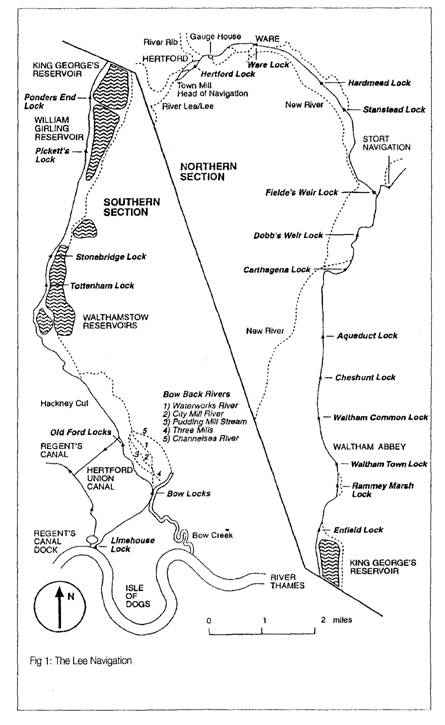
John H Boyes, Published in Papers of the Rolt Fellows Edited by R Angus Buchanan, Bath University Press, 1996 Introduction Lea or Lee - which is correct? Both seem at times to be used indiscriminately to describe the valley and particularly the river which for centuries has formed the major part of the: boundary between Hertfordshire and Middlesex on the west and Essex on the east. The river itself rises further west still in the suburbs of Luton in Bedfordshire and its eastward course from there to Ware follows the pre-first lee Age valley of what was later to be known as the Thames. In that early period the Thames flowed from Marlow in a north-easterly direction towards St Albans and then easterly through Hertford, Ware and central Essex to the North Sea. During the first Ice Age the terminal moraines of the great glaciers dammed the course of the Thames so that a lake was formed in the north of Essex. This eventually burst its banks and generated the present Lea valley and the Thames estuary. Moraines from a later lee Age created the present course of the Thames through London to link with the earlier Thames estuary.1 In the post-glacial period early man settled in the Lea valley to take advantage of the fresh water springs available for the necessities of life and his successors in Saxon times called the river the Lygan or Lygean,2 possibly the bright river. This was later corrupted into various forms including Luy - hence Luton; Ley - hence Leyton; and the Lea. But in 1739 when Parliament created a body of trustees to oversee the maintenance of the navigation the Act referred to the Lee Navigation Trustees. Thus since that time Lea is strictly the spelling for the valley and the original river while Lee refers to the navigation and the artificial cuts made in the valley to facilitate waterborne transport. Hence the distinction in the spelling in the title of this essay. Because of the fertility of the valley bottom, the purity of the water, the value of the current in powering water mills, and the beneficial direction of the river providing an easy communication to the north of London the Lea valley became economically important from very early times But in order to maximise these advantages it has been necessary to improve radically the natural conditions available. This process of improvement has been undertaken by individuals and authorities for over a thousand years and the consequence of some of the early activities still determines the work that has to be done today. As already stated, the River Lea rises near Luton at Leagrave Marsh - a place where the pure spring water attracted a neolithic camp, possibly some 10 acres in extent 3. The river then flows easterly through Luton Hoo Park, Wheathampstead, Hertford to Ware. In its course it receives several tributaries, Mimram, Beane, Rib and Ash, as well as a number of smaller streams. At Ware the river turns south to pass Enfield, Walthamstow, Leyton and West Ham to enter the Thames at Bow Creek. Between Ware and the Thames only one further major tributary is received, the Stort, which also became a legal navigation in 1769.4 In this basin over one hundred watermill sites have been identified emphasising the economic importance of the water supply as a source of energy. The valley itself is fairly wide due to the lateral movement over the centuries of the river bed and the regular flooding of the valley bottom during the winter rains. This has enabled major engineering works to be undertaken without undue difficulty but, on the other hand, it has also limited the number of east-west crossings over the marshland while permitting direct north-south communications. As technical know-how increased and as
administration became more sophisticated so did the nature and scale of
improvements to and modification of the river gather scope and pace.
This is reflected in the three main periods in which different
approaches were made to solve the problems of the time.
The first period - by far the longest - covered the years up to the mid-eighteenth century and was dominated by an ad hoc approach to problems by the local landowners, great and small, and the Commissioners of Sewers using local labour and almost parochial control with inevitable disputes between interested parties. Sometimes recourse was made to higher authority for arbitration and settlement of major controversial matters and for sanction to carry out works but there was no national guidance on methods to be adopted. The second period between the mid-eighteenth century and the second half of the nineteenth century coincided with the rise and fall of national canal construction and well-known names from the newly emergent civil engineering profession, such as Smeaton, Yeoman and Rennie, were called in to advise as consultants. It was in this period that most of the major alterations to the course of the navigation were undertaken. The third period dovetails into the end of the second period by which time the professional engineering knowledge previously found among a limited number of practitioners had spread to a wide spectrum of trained men and the dominance of the few was no longer necessary. It was during this period that the various authorities recruited full-time trained staff who were assisted by specialist consultants and contractors engaged on those occasions when major civil engineering work outside the normal experience of the staff was projected. Although there is no clear-cut division between the periods, the pattern of control can be seen to evolve gradually. In this essay the three periods are dealt with separately but it must be remembered that there is a continuum between them. The financial aspects of the development and the growth of traffic on the navigation will not be considered except incidentally. |
This site was last updated 16/09/09